Overview
Open Atlas Vantage-X is the EUDR analysis tool, designed to assess the compliance status of source-commodity production locations with respect to the European Union Deforestation Regulation (EUDR).
Documentation Overview
The Vantage-X documentation provides articles with detailed information about registering the geolocation of plots of land, risk assessment and the end-to-end tutorial on how to run EUDR risk assessment at scale using Vantage-X API. Additionally, there is an API reference documentation with all the details about every endpoint.
Interface
Vantage-X provides the API to cover the entire flow of deforestation and location-specific legislation risk assessment. The API allows you to:
- Register the plot of land. This includes both polygon and point geolocation.
- Run risk assessment for selected plots of land.
- Retrieve risk assessment results in the form of calculated values and visual representation.
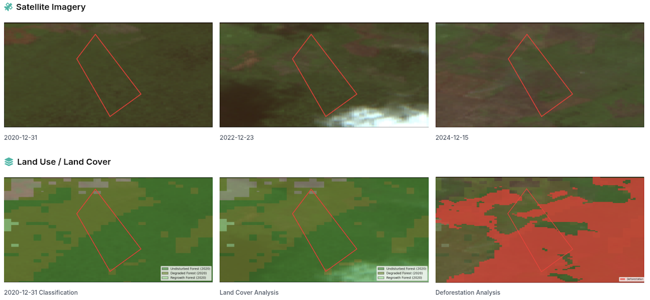
The API allows running analysis globally. The following is the example of a single section of the visual representation of risk assessment.
To access Vantage-X API, you must provide the username and the password.
Please get in touch with us to learn more and access the product.
Tokens
Once you have your account set up, you have a dedicated number of tokens to perform risk assessment. At OpenAtlas, we aim to provide transparent pricing to ensure a straightforward integration. Therefore, for each registered plot, we explicitly provide the number of tokens that will take to run the risk assessment.
You can always access information about the currently available and reserved tokens. This section of the tutorial describes token balance information in more detail.
Mock Service
We understand the importance of running experiments while integrating with OpenAtlas. To support this, we provide a mock service that returns simulated responses for all API endpoints.
- The mock service is free to use.
- It allows testing integration workflows without real data processing.
- The base URL is:
https://api.open-atlas.com/_mock/openapi
This enables you to validate requests and responses before full implementation.
Please note this URL is also used in the API reference documentation for demonstration purposes.
API Versioning
OpenAtlas uses header-based versioning to ensure backward compatibility while introducing new features and improvements. The API version is specified using the X-API-Version header.
Current version: X-API-Version: 3
Starting March 31, 2026, every integration must explicitly send the X-API-Version header. Headerless requests will continue to function briefly but will no longer be auto-promoted, and they will be rejected once enforcement begins on July 1, 2026.
Major version changes are reflected in the version number. OpenAtlas supports the current and previous major versions concurrently before retiring older versions. Deprecations are communicated in advance to ensure a smooth transition.
Version Status and Core Changes
| Version | Status | Core Changes |
|---|---|---|
| 1 | Deprecated | Initial launch version. |
| 2 | Supported (sunsetting July 1, 2026) | Improved risk assessment calculations and minor schema refinements. Headerless callers are expected to set the header by March 31, 2026 and will receive 400 Bad Request responses once enforcement starts on July 1, 2026. |
| 3 | Current | Updated visualisation structure; added advanced Indigenous Peoples and Protected Areas checks. |
Previous versions of the risk assessment visualisation are still available when using API version 2. Responses served with X-API-Version: 2 now include standard HTTP deprecation headers (e.g., Warning, Sunset, Link) notifying clients that version 2 will be decommissioned at 00:01 on July 1, 2026, and that headerless requests must set the X-API-Version header by March 31, 2026 before 400 Bad Request enforcement begins. Please migrate to version 3 to avoid disruption.